
About Thomas Hurd
Lived 1757 – 1823 (aged 65–66). Thomas Hurd was a British naval officer, hydrographer, cartographer and sea captain.
Thomas Hannaford Hurd (bapt. 30 January 1747 – 29 April 1823) was an officer of the Royal Navy, who rose to the rank of captain. As a surveyor, he is noted for his work in Bermuda and the English Channel. He became the second Hydrographer of the Navy, a Superintendent of Chronometers and a Commissioner on the Board of Longitude. Hurd's Deep in the English Channel and the Antarctic Hurd Peninsula are named after him. His establishment of a corps of specialised surveying officers commanding their own ships led to him being described as "the father of the Hydrographic Service".
Life Thomas Hurd was born in Plymouth, and joined the navy in September 1768 at the age of 19. He served as an able seaman aboard , which was then under the command of Captain Molyneux Shuldham. He served on the Newfoundland and North American stations between 1771 and 1774, part of the time aboard the armed vessel , under Lieutenant Henry Mowat. From 1772 to 1775, while with Canceaux, Hurd helped Samuel Holland conduct hydrographic surveys of the mouths of the St. Croix and St John's rivers in the Bay of Fundy. He identified offshore shoals that could be a hazard to shipping, and fixed their positions. He also carried out soundings in Passamaquoddy Bay that were used by Thomas Wright in his map of the area.
Hurd passed his lieutenant's examination on 1 March 1775, and went on to serve aboard Lord Howe's flagship. Howe appointed Hurd as lieutenant of HMS Unicorn on 30 January 1777. Unicorn was a frigate under the command of Captain John Ford, which had a coppered hull. Being free of barnacles she was able to capture a great deal of enemy shipping and Hurd as Lieutenant gathered a large amount of prize money. After Unicorns return to England she was one of the small squadron engaged under Captain Sir James Wallace in setting fire to three enemy ships and taking the French ship Danae, a brig and a sloop as prizes in a minor battle on 13 May 1779 off the French coast at Cancale.
In the Battle of the Saintes off Dominica, on 12 April 1782, Hurd was second lieutenant of the from which he was moved into . Ardent had been recaptured from the French and was one of the prizes. Hurd helped sail her back to England under her commander, Richard Lucas. Darrell would later become the first Black Bermudan to buy a house,
On 18 May, Murray and his captains visited the town of St. George, where they were welcomed with a great reception. In the following week, Hurd and Murray explored the new anchorages, including other possible entrances, and also westwards to Grassy Bay and Ireland Island, which Murray regarded as an ideal location for a dockyard. Murray sent a report to the Admiralty, with detailed recommendations for establishing a naval base on Bermuda. Not all of his suggestions were agreed to at the time, but Bermuda became an established harbour for the squadron, particularly in winter. When the USA declared war on Britain in 1812, the importance of Bermuda greatly increased, and it was the base from which the 1814 attack on Washington was launched. It eventuallly became one of the largest British overseas bases. Hurd received promotion to post captain on 29 April 1802.
Bay of Brest and English Channel Hurd's 1804 survey area from Ile d'Ouessant to Pointe Saint-Mathieu. Detail from Hurd's chart, with islands and salient points highlighted. Brest is about 20km east of Pointe Saint-Mathieu In May 1803, war with France restarted, and William Cornwallis, commanding the channel fleet, resumed the blockade of Brest. In March 1804, a 74-gun ship the struck a submerged rock and was lost, though the crew was rescued. This loss was blamed on inadequate charts, and led to a new survey being planned. Hurd started work on this in June 1804. In the autumn of 1805, westerley winds prevented Hurd from working in the bay of Brest, and he carried out a survey of Falmouth. He returned to French waters in 1806, surveying the area west of Béniguet, and mapping a new channel leading into the Chenal du Four from the west. Two charts from Hurd's surveys were published in 1809, A Nautical Survey of the bay of Brest and the Ushant Islands and A Survey of the New Channel into the Four Channel from the Bay of Brest. Both charts remained in the Admiralty catalogue until the late 1850s, the former in a revised edition published in 1816. Hurd first saw one in 1806, when Spence was using it in the Hydrographic Office in London, and was given permission to order one. A type of extendable protractor, it was particularly useful for plotting multiple soundings whose positions had been determined by horizontal sextant angles between known points, and came into widespread use over the next 10 years. Progress was slow, as the new charts often needed to be compiled from several surveys and from existing charts at different scales, rather than being facsimile reproductions. Dalrymple was also in poor health be this time. In 1807, the Admiralty Board ordered the purchase of all available charts published in England, over 1,000 in all, so that a selection could be made of those that should be issued to the fleet. Dalrymple being unfamiliar with many of the areas covered suggested the formation of a committee to advise on the selection. This was agreed to, and Captains E.N. Columbine, Hurd, and Sir Home Popham were appointed. Relations between Dalrymple and the committee were difficult, and Dalrymple's refusal to cooperate on some issues, and a perception of his declining powers, led to his dismissal by the First Lord of the Admiralty in May 1808. He died three weeks later, aged 70.
Hurd was appointed to take his place, and to implement the recommendations of the Chart Committee. He would hold the position of Hydrographer for 15 years. The war with France continued until 1815, and from 1812 Britain was also at war with the United States. Hurd's first task was getting charts and sailing directions out to the fleet. As noted by historian Adrian Webb, this was a major change of policy, as until then it had been the responsibility of a ship's officers to acquire their own charts. It involved both issuing material already held by the Admiralty and the purchase of charts from commercial publishers. Boxes of charts appropriate to the individual stations were prepared, and sent to the naval depots by stagecoach, to ensure speedy delivery. In the next six months, 113 boxes had been sent out, and storage arrangements made at several dockyards. He was very thorough in obtaining useful information, including instructing the purchase of Spanish maps by a navy ship in Cadiz, purchasing Dalrymple's original copper plates from a scrap metal dealer, and obtaining maps of coastal areas from the Ordnance Survey. Coastal surveys of Britain would soon be linked to the triangulation of the Ordnance survey.
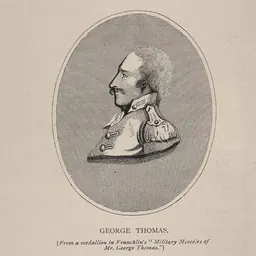
Hurd was very concerned to increase the amount and quality of surveying work carried out. Eventually this would lead to the formation of a dedicated surveying service, but at this stage the Hydrographer still had no remit to commission surveys, and could only make recommendations to the Admiralty. His first concern was with home waters, which had been neglected since Graeme Spence had retired in 1803. Hurd suggested William Chapman, a Master. His appointment was approved, together with the provision of a vessel and instruments - a good chronometer, spyglass, sextant (made by Troughton), quicksilver horizon, and azimuth compass. Unfortunately Chapman died on 2 April 1810, and Hurd recommended George Thomas, also a Master, to replace him. Thomas took command of the newly built in April 1811, and started work surveying the Yarmouth Channels. He would be continually employed in surveying, largely in home waters, until he retired in 1846. Another important area was the western approaches of the English Channel, where Martin White was surveying the Channel Islands. Abroad, surveys continued to be commissioned by the Amiralty or senior officers until 1813, when Hurd recommended that William Henry Smyth be equipped for surveying in Sicily. His work was commended. and he was provided with a vessel in 1816, the , later renamed Adventure, in which he carried out surneys of the Greek archipelago.
In 1814, with peace negotiations in progress, Hurd's attention, as with many other military men, turned towards peacetime policies. He wrote an account of the state of hydrography for the Admiralty in which he drew attention to "the great deficiency of our nautical knowledge in almost every part of the world, but more particularly on the coastline of our own Dominions". He suggested that the time was right to address such issues, given the availability of men and ships as the war drew to a close. Resources were indeed committed to surveying after the war ended in 1815. Two more surveying vessels were commissioned in 1816, and , and HMS Congo was added as a surveying vessel in 1817. Also in 1817, the Admiralty Board established rates of pay for officers carrying out surveys. As Archibald Day, Hydrographer from 1950 to 1955, remarked: "Thus the Royal Navy's surveying service came into being and its pattern has remained unchanged until the day".
Chart of St. Lucea, Branco & Raza, Cape Verde Islands, published 1823, an early chart on public sale Since 1816, Hurd had been arguing for making Admiralty charts available for public sale. The revenue generated would enable the office to pay its employees better wages, and would at least partially insulate it from pressures on public expenditure. It would also benefit merchant mariners, who could directly see the value of the Office's work, and encourage its expansion. This was agreed in principle in 1819, and authorised the following year. Hurd prepared a catalogue in 1821, and agents were appointed to sell the charts, which were published from 1822. The catalogue was not published until 1825.
With peace established, Hurd sought to restore international cooperation in Hydrographic affairs. Dalrymple had known Lieutenant Rossel when he was a prisoner in England in 1795. After the wars, now an Admiral, Rossel was appointed the French Hydrographer, and communication was soon established. In 1817 Hurd sent a collection of Admiralty charts to the Spanish Hydrographic Office in order to encourage mutual exchange of charts, and then established good relations with Poul de Løvenørn, the Danish Hydrographer. This cooperation did not extend to the United States. Even after the war ended, they were still regarded as a threat to British interests. In 1827 Edward Parry, Hurd's successor as Hydrographer, noted that "Captain Hurd objected to publishing this survey [of Bermuda], lest it should fall into the hands of the Americans". Also, charts of the Great Lakes were not published, but only supplied to Royal Navy ships.
Death and legacy Hurd had been in poor health since 1820, and he died on 29 April 1823, while still in office. He was also a superintendent of chronometers and a commissioner for the discovery of longitude. To his wife he left "enslaved people on Grenada and Dominica that had been given and bequeathed to him by his 'worthy and respected friend' Samuel Proudfoot of Clapham Common".
Michael Barritt, Hydrographer of the Navy from 2001 to 2003 notes that no obituary of him was written until a tribute appeared six years later. Barritt agreed with that tribute in praising Hurd's persistent advocacy of the surveying service. Steve Ritchie, Hydrographer from 1966 to 1971 said that Hurd was a shadowy figure, and continued: "But undoubtedly he was the right man for the job of Hydrographer at the time; he was a practical naval officer with no pretensions to science, in fact the only Hydrographer of the nineteenth century who did not become a Fellow of the Royal Society. His very lack of scientific leanings was a help to him in his task." Roger Morris, Hydrographer from 1985 to 1990, says that by the time of Hurd's death "surveys ordered by the Hydrographer were being made by a corps of specialised seamen Naval officers commanding their own ships which were themselves specially fitted out for surveying. If Dalrymple is the father of the Admiralty Chart, Hurd is undoubtedly the father of the Hydrographic Service."
The Hurd Peninsula is on the south coast of Livingston Island, in the South Shetland Islands. It was named by the UK Antarctic Place-Names Committee in 1961, for Thomas Hurd, RN. Hurd was chosen as it was under his authority that Antarctica was discovered. Hurd's Deep in the English Channel was also named after him.
Don’t just read it —
keep it.
Full-length biographies made to live with: read them, listen on the way to work, watch them tonight.
- E-book
- Audio
- Video
Instant download · yours to keep · every purchase keeps this site free
Important facts
People in Thomas Hurd's life
Named in this biography and alive at the same time




Related people
Same field, nearest in time





Contemporaries
People whose lives overlapped Thomas Hurd's


Frequently asked questions
Who was Thomas Hurd?
British Royal Navy officer
When was Thomas Hurd born?
Thomas Hurd was born in 1757 in Plymouth.
When did Thomas Hurd die?
Thomas Hurd died on 29 April 1823 in London.
What was Thomas Hurd's occupation?
Thomas Hurd was a naval officer, hydrographer, cartographer and sea captain.
What nationality was Thomas Hurd?
Thomas Hurd was British.
Sources & further reading
Cite this page
APA: Biography.guide. (2026). Thomas Hurd. https://biography.guide/thomas-hurd/
MLA: "Thomas Hurd." Biography.guide, https://biography.guide/thomas-hurd/.
Chicago: "Thomas Hurd." Biography.guide. https://biography.guide/thomas-hurd/.
Data last updated: 2026-09-25 · Spot an error? Report a correction.
Page generated 2026-09-27 05:11 UTC