
About Istakhri
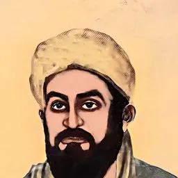
Lived 850 – 957 (aged 106–107). Istakhri was a geographer, cartographer and traveler.
Life and background It is believed that al-Istakhri is from the town of Istakahr, an ancient city in the southwestern province of Fars. There is no consensus regarding his origin. The Encyclopedia Iranica states, "Biographical data are very meager. From his nesbas (attributive names) he appears to have been a native of Eṣṭaḵr in Fārs, but it is not known whether he was Persian". Some sources describe him as Persian, while others state he was Arab. Most of his works were written in Arabic and then later translated to Persian. This translation possibly facilitated his works becoming an inspiration for other Persian geographers of the time. Another illuminated manuscript dated AH 706 (AD 1306–07) now resides in the Khalili Collection of Islamic Art. It contains many maps, though some mentioned in the text are missing. Ṣuwar al-ʿAqālīm (, Pictures of the Regions), A Persian treatise of geography. Thought to be a representation of Spain, the text included with the image refers to Spanish territory under the rule of the Umayyads of Cordoba. This gives a reference to the times of 756 CE - 1031 CE. While this image was innovative at the time of its creation, there are some incorrect locations and errors throughout.
Historical context Ptolomy’s map, which inspired Islamic and European mapmakers, including Istakhri and al-Balkhi. In the 9th century, around 150 years after the founding of Islam, Arabic translations of Ptolemy's Geography sparked Islamic interest in the literature of cartography and geographical descriptions. In addition, Arabic geographers utilized the ancient Iranian concept of the seven climes, a system which organized the world into broad regions and informed how Islamic scholars described space. The Abbasid period was increasingly concerned with cartographical improvement to address the needs of administrations and businesses as well as to be able to locate Mecca easily.
The Balkhi tradition Later Arabic cartographers shifted away from the Ptolemaic past to embrace new forms of symbolic mapping. Istakhri belonged to and helped to popularize the Balkhi school, inspired by the earlier works of Ibn Kurradadhbih and the Iraqi school. Map divisions were largely territorial and material; however, since few of al-Balkhi's geographical treatises survive, their influence on Istakhri has been long contested. Before 921 CE, Istakhri stated he had completed commentaries on Balkhi's maps and expanded upon them in 933 CE and 951 CE.
Manuscript tradition While scholars have referred to the category of illustrated maps associated with al-Istakhri as the Atlas of Islam, some modern scholars like Karen Pinto prefer to call it the KMMS tradition. The acronym comes from the first letter of each word of the Arabic title of his Book of Roads and Kingdoms (Kitāb al-masālik wa-al-mamālik) combined with the first letter of the Arabic word for picture (ṣūrat). Istakhri methodically sections off regional entities that have boundaries and ascribes them to them certain political and religious meanings. There are also personal anecdotes scattered throughout the text as well. Istakhri discusses how highly he held the values of the structure of the kingdom, good manners, law and order, and the organization of settled life, for example as seen through his writings on the Beja people. He orients the map with the south at the top and draws each Islamic region using shapes and colors; for example, rivers are dark brown and cities are depicted as circles and rectangles. He does not use a drawing scale like latitude and longitude but often maintains proper proportionality and directionality, with distance measured by the time taken to travel between locations. However, the surviving drawings differ by region in condition and thoroughness.
Published editions An 8-volume edition of works by medieval Arab geographers, edited by the Dutch orientalist Michael Jan de Goeje in a series titled Bibliotheca geographorum Arabicorum was published by Brill, Lugduni-Batavora (Leiden) in the 1870s. An edition of Istakhri's MS text was produced for the first volume under the Latin title Viae Regnorum descriptio ditionis Moslemicae – "Description of Roads of the Kingdoms in Muslim territories". In 1927, the editor Theodore Noldeke produced a second edition. In 1845, the German orientalist A. D. Mordtmann published a translation in Hamburg with the title Das Buch der Länder von Schech Ebu Ishak el Farsi el Isztachri, with a foreword by C. Ritter. (Schriften der Akademie von Ham Bd. 1, Abth. 2).
Don’t just read it —
keep it.
Full-length biographies made to live with: read them, listen on the way to work, watch them tonight.
- E-book
- Audio
- Video
Instant download · yours to keep · every purchase keeps this site free
Important facts
Related people
Same field, nearest in time


Contemporaries
People whose lives overlapped Istakhri's



Frequently asked questions
Who was Istakhri?
Iranian geographer
When was Istakhri born?
Istakhri was born in 850 in Istakhr.
When did Istakhri die?
Istakhri died in 957.
What was Istakhri's occupation?
Istakhri was a geographer, cartographer and traveler.
What nationality was Istakhri?
Istakhri's recorded nationality: Samanid Empire.
Sources & further reading
Cite this page
APA: Biography.guide. (2026). Istakhri. https://biography.guide/istakhri/
MLA: "Istakhri." Biography.guide, https://biography.guide/istakhri/.
Chicago: "Istakhri." Biography.guide. https://biography.guide/istakhri/.
Data last updated: 2026-09-20 · Spot an error? Report a correction.
Page generated 2026-09-27 05:06 UTC