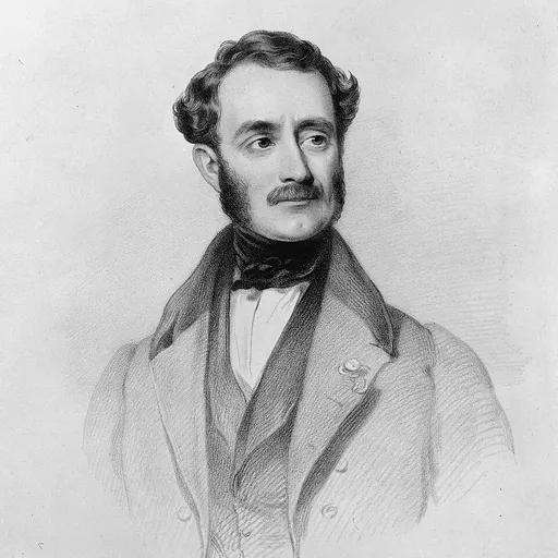
Joseph Thomas
New Zealand surveyor
About Joseph Thomas
Born 1803. Joseph Thomas was a New Zealand surveyor, known for Canterbury Association and New Zealand Company.
New Zealand Thomas purchased land in Wellington from the New Zealand Company and arrived there on the Adelaide on 7 March 1840. As the land proved to be unavailable, he ventured into fishing and whaling, but in 1841 accepted a survey position under William Mein Smith. Thomas undertook work in Wanganui and Porirua, but together with most of his colleagues, he was sacked by chief surveyor Samuel Brees in March 1843. In the following year, he was engaged to undertake survey work in the Otago region under Frederick Tuckett, but the work was postponed and he explored parts of the North Island instead. Thomas' remit included to find the site of the settlement anywhere in New Zealand, and it appears that the Canterbury Association expected that land in the Wairarapa be taken up, but he was instructed to obtain the consent of both the Governor (George Grey) and of Bishop Selwyn. Other instructions to Thomas included that the settlement should have a land area of at least , with at least of that available for agriculture. The settlement could be at the coast or inland, but any coastal settlement required a good harbour, and the port should preferably be the capital. The capital was to be called Christchurch.
Thomas may have had preconceived ideas about the location of the desired settlement, as he mentioned to a Nelson settler that the question is about "Port Cooper or nothing", with the name referring to what is now known as Lyttelton. In Nelson, he organised a copy of the report written by George Duppa of his 1841 exploration of Port Cooper and the adjacent plains. He reported to the Canterbury Organisation that the land question between Kaikōura and Otago had been resolved (through Kemp's Deed, where the New Zealand Company had bought the land of the Māori), whereas the government was still trying to purchase the land in the Wairarapa from the Māori, hence lessening delays "should we decide on Port Cooper".
+ Sortable and collapsible table Name given by Thomas Named for Canterbury Association member Present name Buccleugh yes Buccleuch (locality) Christchurch no Christchurch, but originally placed at present-day Teddington Godley Head yes Awaroa / Godley Head Goulburn yes the town was not built Governor Grey no Mount Grey / Maukatere Harewood Forest yes Oxford Forest Lake Coleridge and William Coleridge yes Lake Coleridge Lake Ellesmere yes Lake Ellesmere / Te Waihora Lake Forsyth yes Lake Forsyth / Wairewa Lincoln yes Lincoln, but originally placed near the mouth of the Selwyn River / Waikirikiri Malvern Hills , where Wakefield first met Godley and thus laid the foundation of Canterbury no Malvern Hills Mandeville yes the town was not built Mount Herbert yes Mount Herbert / Te Ahu Patiki Mount Hutt yes Mount Hutt Mount Richards yes Steepface Hill Mount Somers yes Mount Somers / Te Kiekie Mount Talbot yes Mount Talbot Oxford (Bishop of Oxford), or Oxford in England, or University of Oxford unclear Oxford Port Albert no Port Levy / Koukourarata Port Lyttelton yes Lyttelton, but originally placed at present-day Rāpaki Port Victoria no Lyttelton Harbour / Whakaraupō River Ashburton yes Ashburton River / Hakatere River Ashley yes Ashley River / Rakahuri River Cholmondeley yes Rakaia River River Courtenay yes Waimakariri River River Cust yes Cust River River Eyre Edward John Eyre no Eyre River River Farquhar yes Saltwater Creek River Halswell yes Halswell River / Huritini River Hawkins yes Hawkins River River Heathcote yes Ōpāwaho / Heathcote River River Selwyn no Selwyn River / Waikirikiri Snowy Range no ? Stratford , the birthplace of William Shakespeare no the site was used for Christchurch Sumner Plain yes Canterbury Plains Whateley Plains yes Canterbury Plains Wilberforce Plain and Samuel Wilberforce yes Canterbury Plains
Thomas went to Wellington next, where he arrived on 21 November 1848. He met with the governor, who advised him that Captain John Lort Stokes of HMS Acheron had just finished a survey of the coast of Hawke's Bay, and that he had instructed him to survey the coast near Port Cooper. William Fox as the New Zealand Company's agent accompanied the three surveyors on the journey, and they reached Port Cooper on 15 December 1848. They undertook a very thorough exploration of the various parts of what is now Canterbury, from near the Waipara River in the north to the Ashburton River / Hakatere in the south, from the coast to the foothills of the Southern Alps. Thomas himself explored Banks Peninsula on foot and went to Port Levy, Pigeon Bay, Akaroa, Little River and back via the inland shore of Lake Ellesmere / Te Waihora. Their own report was supplemented by a report from the Deans brothers, who at that time were the only white settlers on the Canterbury Plains, with their farm located at Riccarton. Thomas and Fox jointly approved land holdings for two parties of settlers already in the area, who had paid for land in the Wellington area which had not been available. The Deans brothers were granted , and the Rhodes brothers (William Barnard and George) were granted in Purau. Fox reported the following to T. C. Harrington, the secretary of the New Zealand Company:
Mr Thomas not only concurred in these arrangements, but was anxious to have them entered into, believing, as I do, that the presence of Messrs Deans and Mr George Rhodes with their stock and farms and their knowledge of climate, seasons, etc., will prove most valuable to the Canterbury immigrants in the early days of the settlement. They are all experienced settlers, hardy pioneers, and intelligent, respectable gentlemen.
Everything proved very satisfactory for a new settlement, and the only possible obstacle was whether the harbour itself was going to be part of the land claim that the French initiative that resulted in the settlement of Akaroa had made. Fox applied to the governor for a ruling. During May 1849, both the Bishop and the Governor gave their approvals of the settlement for the Canterbury Association, and Grey thus confirmed that Port Cooper was not going to be part of the French land claim any longer.
To conform with his instructions, Thomas initially placed the settlement's capital at the head of Lyttelton Harbour / Whakaraupō at the present-day Teddington. Mandeville was never built, and the land at Rāpaki was not available, as it had been promised to Maori as a reserve. Sites for other town, to be built later, were identified for Lincoln (near where the Selwyn River / Waikirikiri flows into Lake Ellesmere / Te Waihora; it was later built in a different location), Oxford (where the college was supposed to be located; the college was built in Christchurch instead), and Buccleugh (which was never built, but which exists as an uninhabited locality named Buccleuch at ).
The three towns that were surveyed were first Lyttelton, then Sumner, and lastly Christchurch. Except for early survey work in Lyttelton, which was done by Thomas and Torlesse, the work was done by Edward Jollie, who explains in his diary how the streets got their names:
The names of the streets of the three towns I surveyed were taken from Bishoprics and the way it was done was this; as soon as I completed the map I took it to Thomas who putting on his gold spectacles and opening his would read out a Bishop's name to hear if it sounded well. If I agreed with him that it did, I put the name to one of the streets requiring baptism.
Lyttelton being the first born town got the best names for its streets, Sumner being next had the next best and Christchurch being the youngest had to be content with chiefly Irish and Colonial bishoprics as names for its streets. This accounts for, what to anyone not knowing the circumstances, appears strange, viz: that many of the best English Bishoprics are not represented while Irish and Colonial ones are. Sumner in fact died too late for the names there used to be again employed in Christchurch.
What Jollie referred to with 'Sumner dying' refers to the fact that the survey was not used, as Godley put the proposal on hold. Instead, the land in Sumner was sold as a rural block.
Later years Thomas moved to Wellington and applied for land in the North Island. to plead his case to the management committee of the Canterbury Association
It is not known exactly what he did after this; according to some reports, he died while in Wellington sometime during the 1880s, whilst others say that he died in Victoria, Australia at an unknown date.
Don’t just read it —
keep it.
Full-length biographies made to live with: read them, listen on the way to work, watch them tonight.
- E-book
- Audio
- Video
Instant download · yours to keep · every purchase keeps this site free
Important facts
Related people
Same field, nearest in time




Frequently asked questions
Who was Joseph Thomas?
New Zealand surveyor (1803-)
When was Joseph Thomas born?
Joseph Thomas was born in 1803 in Worcester.
What was Joseph Thomas's occupation?
Joseph Thomas was a surveyor.
What was Joseph Thomas known for?
Joseph Thomas was known for Canterbury Association and New Zealand Company.
What nationality was Joseph Thomas?
Joseph Thomas was New Zealand.
Sources & further reading
· DBpedia: Joseph Thomas (surveyor)
Cite this page
APA: Biography.guide. (2026). Joseph Thomas. https://biography.guide/joseph-thomas/
MLA: "Joseph Thomas." Biography.guide, https://biography.guide/joseph-thomas/.
Chicago: "Joseph Thomas." Biography.guide. https://biography.guide/joseph-thomas/.
Data last updated: 2026-09-23 · Spot an error? Report a correction.
Portrait: Wikimedia Commons · author & licence
Page generated 2026-09-27 05:05 UTC