About Hernando de los Ríos Coronel
Hernando de los Ríos Coronel was a cartographer.
Hernando de los Ríos Coronel (1559 –1621? ) was a mathematician, cosmographer, cartographer, navigator, naval pilot, administrator, soldier, priest, and advocate (procurator general) at the Spanish court of the inhabitants of the Philippines from 1606 to 1610 and again from 1618 until his death.
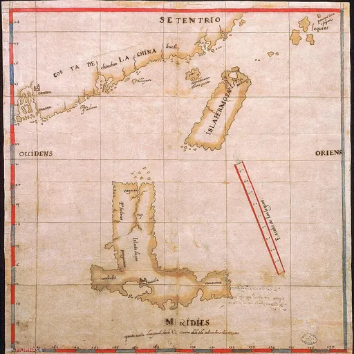
Having attained the rank of military captain, he accompanied governor Luis Pérez Dasmariñas on his expedition to Luzon and Cambodia and spent time in China in 1597. There he prepared the first map of Luzon, Taiwan (also known as Formosa or Isla Hermosa) and certain areas of the Chinese coast. As navigator
De los Ríos Coronel combined his expertise as navigator with those of an experimenter which was a common practice at the time. He had received renewed impulse with the founding of the Spanish Royal Academy of Sciences in Madrid. His scientific developments aimed to update instruments and tables for navigation based on astronomical observation, combined with an attempt to determine the geographical longitude at sea.
Two examples where he combined his expertise as a navigator with those of an experimenter, are of the development of a process of enabling the extraction of sweetwater from seawater while at sea, for which he requested a license
By the end of 1598, Dasmariñas' plans to continue to Cambodia were thwarted by Captain Paulo de Portugal, who opposed the Spanish. Juan Zamudio returned to the Philippines, requesting help for the Cambodia expedition, but Governor Francisco Tello, lacking resources, ordered Dasmariñas to return to Manila.
As cosmographer and mapmaker Originally, cosmography had the meaning of protoscience of mapping the general features of the cosmos, heaven and Earth, thus a cosmographer combined map making (i.e. cartographer) with scientific experiments aimed to update instruments and tables for a wide range of applications. de los Ríos Coronel drew the first map of the islands of Taiwan (Hermosa o Formosa), Luzón and the Chinese coast. The map is oriented north to south and west to east. It depicts the main island of Luzon (currently part of Philippines) on the bottom of the map, including Manila and Manila Bay; Cagayan is spelt as cagaian on the map.
Taiwan is depicted at the top of the map as 'Isla Hermosa' (lit. beautiful island in Spanish). While on the top right corner of the island is the Port of Keelung (Puerto de Keilang). Also in the top right corner, the Ryukyu Islands are depicted, which are named Lequios and writing por aqui sera a Japon.
On the top left corner of the map he depicts the locations of Canton (modern Guangzhou and Macau).
Don’t just read it —
keep it.
Full-length biographies made to live with: read them, listen on the way to work, watch them tonight.
- E-book
- Audio
- Video
Instant download · yours to keep · every purchase keeps this site free
Important facts
Related people
Same field, nearest in time



Frequently asked questions
Who was Hernando de los Ríos Coronel?
Spanish cartographer
What was Hernando de los Ríos Coronel's occupation?
Hernando de los Ríos Coronel was a cartographer.
Sources & further reading
· Wikipedia: Hernando de los Ríos Coronel
· DBpedia: Hernando de los Ríos Coronel
Cite this page
APA: Biography.guide. (2026). Hernando de los Ríos Coronel. https://biography.guide/hernando-de-los-rios-coronel/
MLA: "Hernando de los Ríos Coronel." Biography.guide, https://biography.guide/hernando-de-los-rios-coronel/.
Chicago: "Hernando de los Ríos Coronel." Biography.guide. https://biography.guide/hernando-de-los-rios-coronel/.
Data last updated: 2026-09-23 · Spot an error? Report a correction.
Portrait: Wikimedia Commons · author & licence
Page generated 2026-09-27 05:04 UTC